From GeoTIFF Chaos to Cloud-Native Climate Risk: How Eoliann Built Airis on Earthmover

COO
The Challenge
Eoliann builds proprietary climate risk models that estimate the physical impact of extreme weather events — floods, wildfires, and storms — on critical physical infrastructure: electricity transmission lines, substations, and gas pipelines. Their customers include some of Europe’s largest infrastructure operators, public and private.
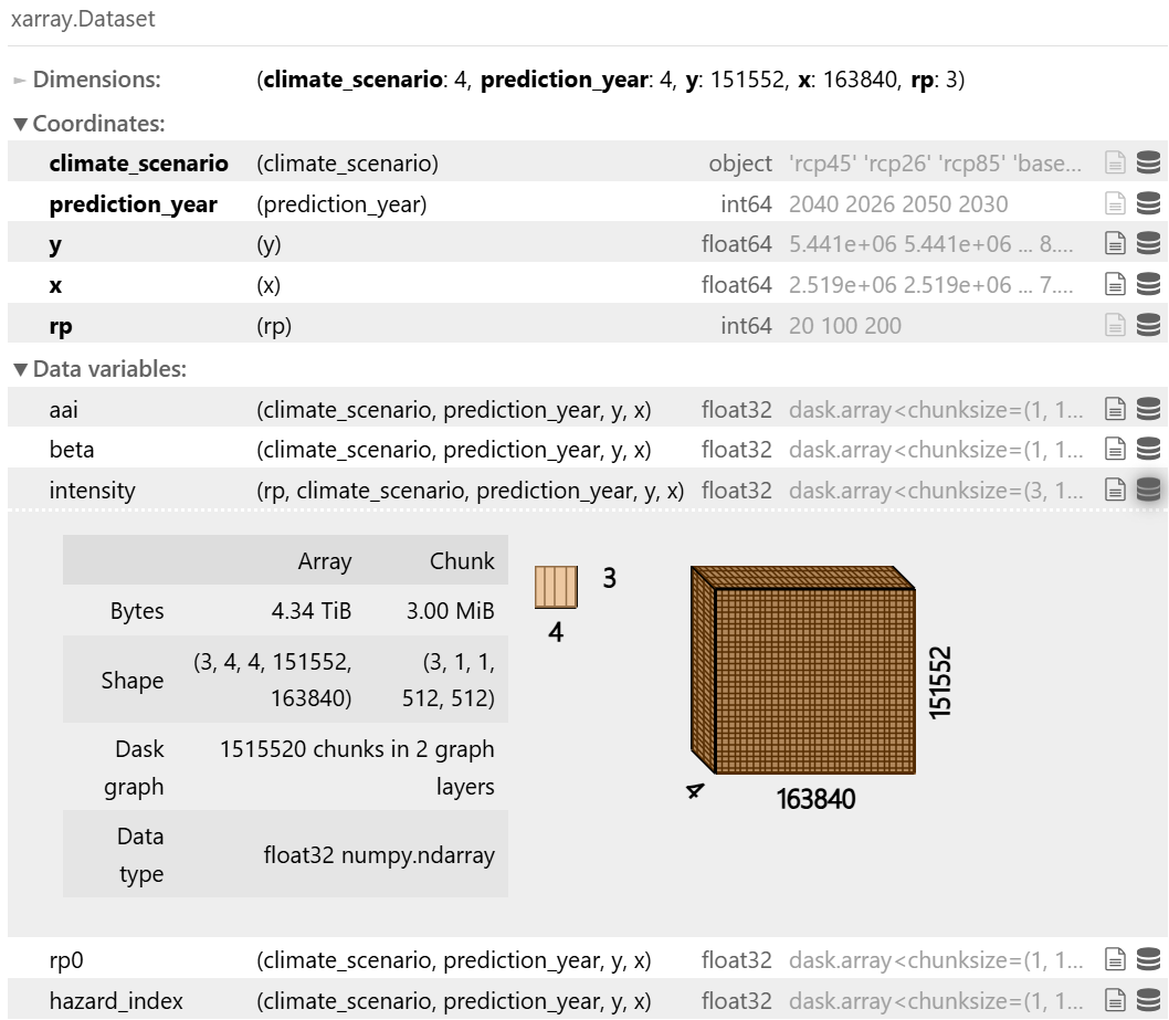
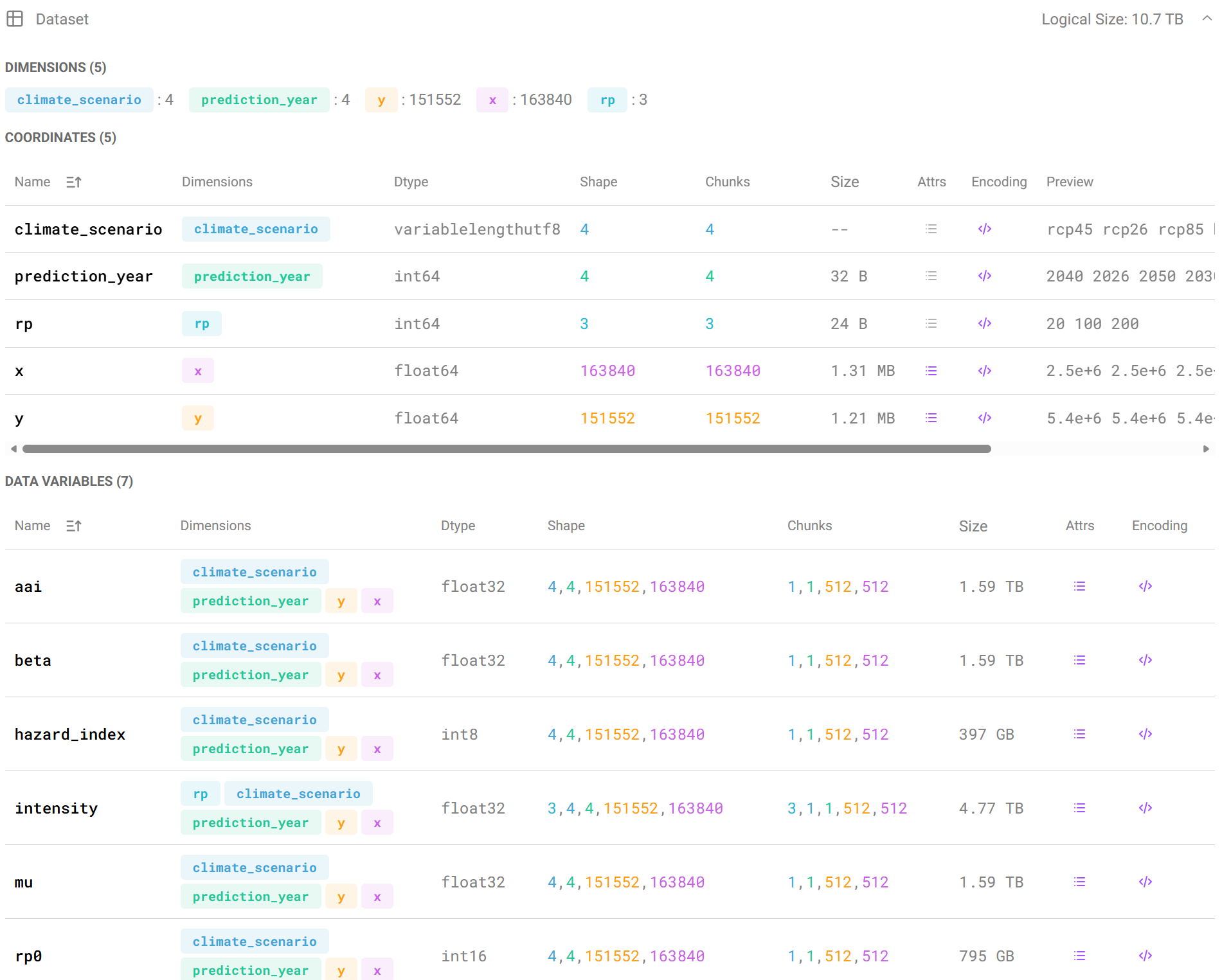
Their original stack, built around GeoTIFF files, did not support necessary analytic operations across enormous, multi-dimensional raster datasets covering European geographies at 30-meter resolution, across dozens of climate scenarios and time horizons.
“Our previous stack relied on GeoTIFF, which is not a cloud-native format and doesn’t fit modern distributed systems. It lacks support for parallel reads and writes, forcing us to generate tiles separately and then merge them — an inefficient and repetitive process. It also limited scalability, making it complex to add new areas, and lacks support for higher-dimensional data like time series. This made it difficult to evolve toward more advanced, future-proof use cases.”
— Paolo Melissari, Data Engineer, Eoliann
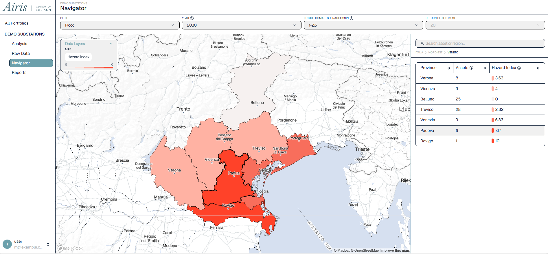
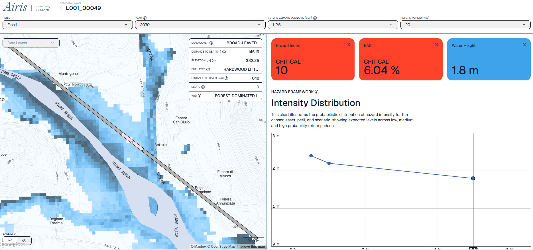
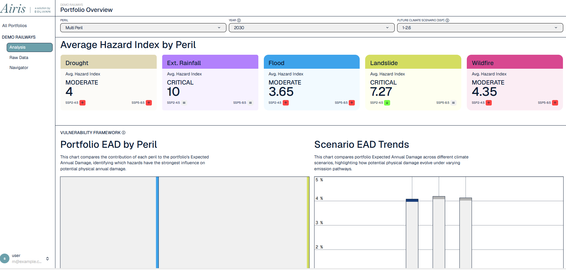
Adding to the complexity: Eoliann also wanted to serve raster data via interactive maps to end users, sample vectorial asset data (points, lines) against raster hazard datasets, and ensure that multiple internal services were always reading from consistent, versioned snapshots of the data — integral to the development of their commercial cloud-based software product, Airis.
 Courtesy: Eoliann
Finding Earthmover
Paolo spent roughly a month researching alternatives to the GeoTIFF stack. The search started with the format problem: how to store and access large, multi-dimensional scientific datasets in the cloud, which led him to Zarr. From there, Earthmover’s blog posts surfaced as a resource that clearly addressed what Eoliann needed.
“We came for some very specific needs — organizing an n-dimensional data store with accessibility in mind. But then something else happened. There were features already embedded in the product that enabled us to do things we hadn’t really thought about — problems we would have had that just didn’t happen.”
— Giovanni Luddeni, CTO and Co-Founder
Their Earthmover proof-of-concept lasted one day.
“I remember that I found Earthmover, I talked with Giovanni, we saw the features, and we basically said: that’s everything that we need. We were opening the documentation and every page was something we actually needed. We asked for a week for a pilot but we validated in one day.”
— Paolo Melissari, Data Engineer
 Courtesy: Eoliann
Eoliann and Earthmover
Eoliann adopted Earthmover as the backbone of their entire geospatial data infrastructure, using it to:
- Store and catalog multi-dimensional raster datasets using Zarr and Icechunk, covering multiple scenarios (probabilistic scenarios, future climate scenarios, future years) across European geographies
- Serve interactive maps via Earthmover’s Flux serving layer, powering the map views inside the recently launched Airis, their commercial climate risk dashboard
- Version datasets using Icechunk, ensuring that raster data and tabular outputs always reflect the same underlying snapshot, even when consumed by different services
- Sample vectorial asset data on raster grids using GeoParquet and the Xarray/XVec ecosystem, translating client infrastructure portfolios (substations as points, transmission lines as linestrings) into inputs for Eoliann’s impact models
The versioning capability, in particular, turned out to be far more valuable to Eoliann than anticipated. Without it, keeping map outputs and tabular risk tables synchronized across services would have required a custom-built solution. Instead, Icechunk handled it transparently.
“I thought: I hope it ever happens for one of our customers to feel this feeling — that this was a bullet dodged, but not a little bit. Like, we never saw the bullet. Icechunk is that good.”
— Giovanni Luddeni, CTO and Co-Founder
When Eoliann wanted Flux to support separate production and development environments with more aggressive performance characteristics ahead of the commercial launch for Airis, Earthmover’s engineering team resolved it within a week.
“The goal for Eoliann that quarter was to make Airis ready for the market, and to do that we needed Flux to be scalable and manageable. Then the week after, the Earthmover team fixed everything. Right now, the map serving is very good.”
— Paolo Melissari, Data Engineer
 Courtesy: Eoliann
Support and Partnership
From the beginning, Eoliann experienced the relationship with Earthmover as something closer to a co-investment than a typical vendor arrangement. Paolo was in the Earthmover Slack channel multiple times a day during the first several months — and found the team consistently responsive and technically sharp.
“I was writing to your Slack channel three times a day for the first three or four months, and everyone was extremely helpful. And because Earthmover works so closely with open source, I could actually see the PRs — it removes every kind of black box. I know exactly how you are working.”
— Paolo Melissari, Data Engineer
That transparency went both ways. Paolo has since opened a pull request contributing back to EDR, the open standard underlying parts of Earthmover’s serving layer. At the Zarr Summit in Rome in October 2025, an event Earthmover helped organize, Paolo saw attendees actively seeking out the Earthmover team to thank them for the quality of the documentation and blog resources.
“Earthmover is the only place right now where you can find a lot of information about how to manage tensor datasets. A lot of people at the Zarr Summit were just searching for Ryan and Joe and Seba and Tom to say thanks.”
— Paolo Melissari, Data Engineer
“The reason I would really recommend it is honestly the way you treat us. Your team is phenomenal — everyone is very helpful, very skilled. We get useful answers very quickly, very on point. That kind of support is very valuable.”
— Giovanni Luddeni, CTO and Co-Founder
The depth of the relationship also shaped how Eoliann thinks about their own partner ecosystem. When a potential data partner recently told Giovanni they could discuss “what format you want us to serve the data in,” his answer was immediate: there was nothing to discuss. “Earthmover is already the answer.”
 Courtesy: Eoliann
Results
Eoliann launched Airis, their commercial climate risk platform for infrastructure operators, on schedule in March 2026. Key outcomes include:
-
Faster time-to-insight for clients: External frontend developers were able to query and render Eoliann’s hazard maps via Flux using only the documentation, before Eoliann’s own team had finished ingesting the full dataset. Map serving was never a blocker.
“Earthmover is the one investment we made that I’m absolutely most certain about the return.”
— Giovanni Luddeni, CTO and Co-Founder
-
Dataset complexity scaled without friction: When Eoliann expanded a 2D hazard layer across 10 years of climate scenarios, multiplying dataset size roughly a thousandfold, the migration took days rather than weeks.
“Doing this one year ago, we couldn’t do it. I did it a week ago, no problem ever.”
— Paolo Melissari, Data Engineer
-
Engineering capacity preserved: The team estimates they avoided hiring two additional engineers to manage data ops — capacity that stayed focused on model development and product instead.
“It’s like the Databricks of geospatial data. You don’t need to hire twice — you can just focus on creating the data.”
— Paolo Melissari, Data Engineer
-
Organic internal adoption: Eoliann’s climate scientists are now using ERA5 data through the Earthmover marketplace, finding it faster for current queries than the team’s own previously built internal tooling.
-
Near-real-time modeling now in scope: With the foundational data infrastructure stable, Eoliann is actively developing near-real-time event assessment: ingesting live hazard intensity data from external providers and running on-demand impact inference.
“For each of these possibilities, we just know that if we need a map, just put it on Earthmover. You already have your endpoint working.”
— Paolo Melissari, Data Engineer
-
Successful commercial launch: Airis launched to the market in March 2026 and is generating inbound interest from infrastructure operators and public sector organizations.
Eoliann is a climate risk intelligence company based in Italy, helping infrastructure operators understand and quantify their exposure to physical climate hazards. Learn more at eoliann.com.
COO